I got to the parking lot before anyone else, which was the whole point. Winter mornings up here, the mist pools in the valleys overnight and sits there on the lower slopes, thick and white, while the ridgelines lift clear out of it into a hard blue sky. I’d seen it before. I came early anyway, to have it to myself for a few minutes before 15 fellow hikers arrived and turned it back into a hike.
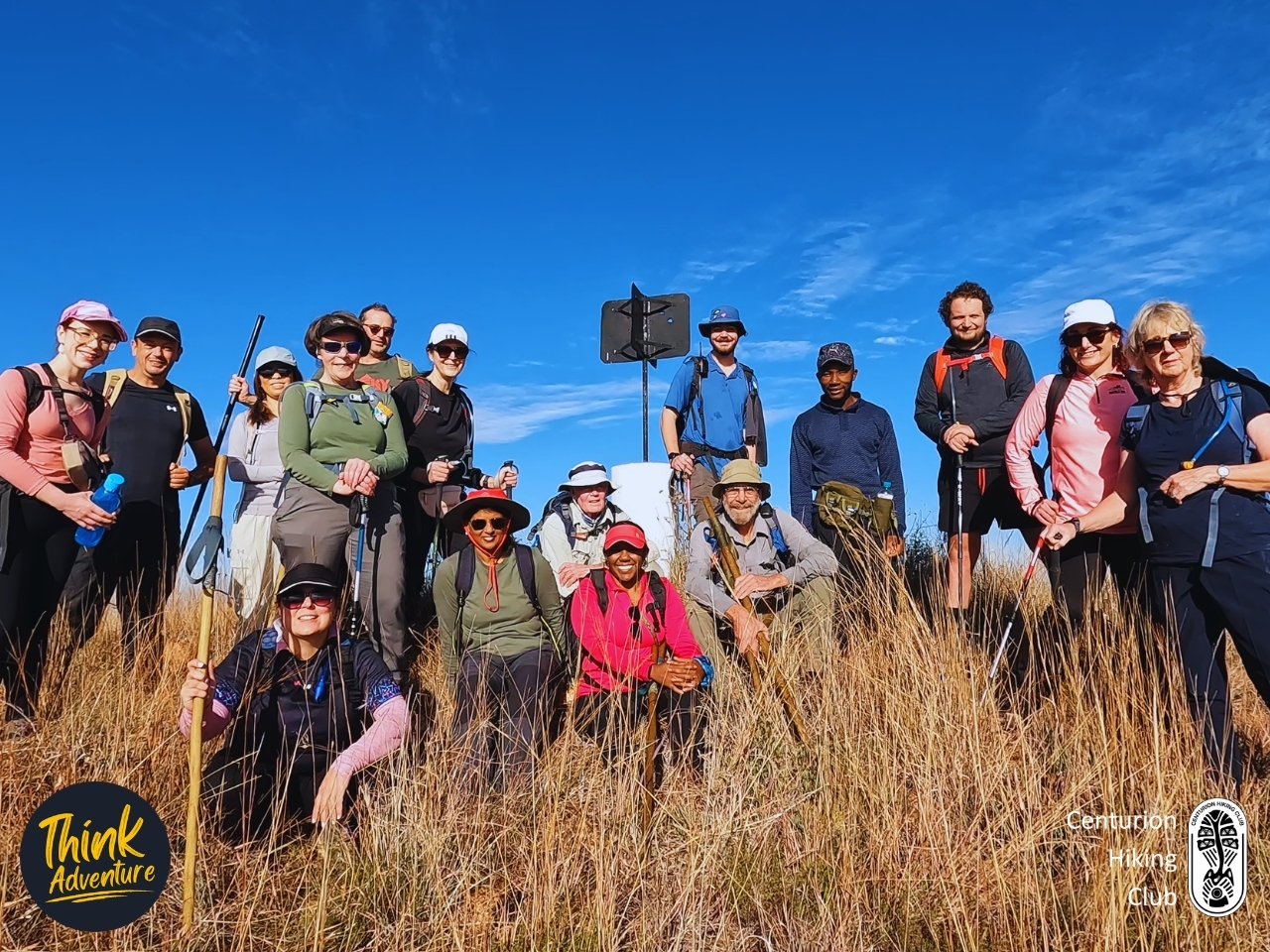
Hoogland sits in the Schurveberg, on the quiet edge of Centurion — 35 minutes from my front door, the last 6.4km of it on dirt. It was a Centurion Hiking Club outing, 16 of us in the end, plus Zwi guiding from the Hoogland side and a fellow club leader along with me. Sunny but cool. The others trickled in one by one, the usual mix of familiar faces and a few new ones, gear sorted, a quick group photo, and we were walking just after eight.
Hoogland doesn’t ease you in. The climb starts more or less where the cars stop — no flat warm-up, no gentle first kilometre to find your legs. You just start going up.
The gradient is forgiving, though, more a long steady pull than anything brutal, and in places the rock has arranged itself into something close to stairs — natural steps you take one at a time. I had a new pair of Merrell trail runners on, first proper outing for them, and the grip earned its money on those sections. My legs felt good. Strong the whole way, which isn’t always how these mornings go.
Zwi and I set the pace up front while my fellow club leader helped keep it together from the back, the two of us on walkies. With 16 people the group naturally wants to stretch out — strong walkers pulling ahead, others finding their rhythm further back — so we worked it in short pushes. Up 10 metres, stop, let everyone gather, move again. It’s not glamorous but it keeps a group together, and nobody ends up alone on a mountain wondering where the rest went.
About 200 metres below the beacon the path runs alongside a fence, and the mist I’d watched from the parking lot was still down there, lower now, the valleys full of it. I stopped for the photo.
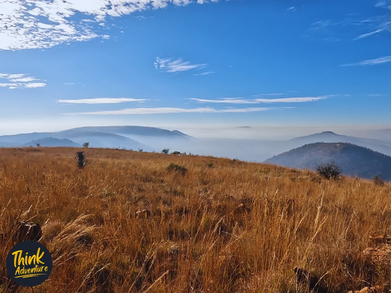
The Dolomite Beacon is one of two high points on the property — 283 metres of climb from the base, and that morning the air was clear enough to see all the way to Pelindaba, out toward Hartbeespoort. The wind had dropped to nothing. There was that easy chatter of a group enjoying itself, people catching their breath and taking it in. We rested, took the group photo, and then turned to make our way down toward the cave.
At the cave entrance the packs came off. Torches out, cameras ready, and Zwi — who is working toward a degree in Nature Conservation — led the way in. You don’t go in here without a guide. Partly because it’s dangerous, and partly because the caves are still being studied, and the people doing the studying would rather 16 pairs of boots didn’t go tramping through their research.
It doesn’t open into a cathedral. The entrance to the Main Cave drops low, and you follow it maybe 20 metres before the floor simply stops — a hole, dropping 6 metres straight into the ground. A rope hung down the left side of it. And the bottom of that drop isn’t the bottom: from there you can keep walking, deeper, further into the earth. How far? Zwi didn’t know. “A long way” was as specific as it got, and somehow that was better than a number.
The chamber is big enough to stand in, and we were allowed up to the edge of the drop and no further. So that’s what we did — took turns at the lip, leaning over to look down into the dark the torchlight didn’t reach the end of. We took photos. A few selfies. There was a lot of chatter, the sound of a group enjoying itself in a strange place. The air down there is cold and smells of wet — that mineral, underground damp that doesn’t exist anywhere up in the sun.
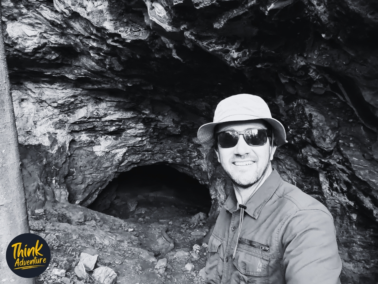
We spent about 15 minutes inside before heading back out to the entrance, where Zwi dropped some knowledge on us. They’ve found fossils in this cave — animals nobody has identified yet, still being researched. He pointed out more of them on the way out, embedded right there in the rock at the entrance, where you’d never notice them on your own. You stand there having just looked into a hole that drops away further than your guide can tell you, looking at the bones of something nobody can name. That’ll reorganise your sense of the place.
I’ve hiked Hoogland a few times now. It’s where the tough, challenging Beacon to Beacon route lives — the one we use to prep for multiday projects — so I came into Sunday knowing the property rewards the effort.
Hoogland is a network of trails you can wander more or less as you please, self-guided. But the Cave hike has to be done with a Hoogland guide. It’s short, but the elevation makes it more than a stroll. If you hike regularly, you’ll be fine — a steady climb with a few ups and downs along the way, nothing that’ll break you. If you don’t, expect it to test you, especially early on when the climb starts the moment you leave the cars. This isn’t a trail for someone who wants flat and easy.
One thing to set expectations on: the cave itself is a quick in and out. Think of it as a micro cave next to somewhere like the Sudwala Caves — not a proper underground expedition, just a 15-minute look into something wild and still being studied before you walk back into the light. If you arrive expecting a show cave with walkways and lighting, you’ll be disappointed. Arrive expecting a hole in a mountain that’s still being researched, and that’s exactly what you’ll get.
Would I go back? I already have, more than once, and I’ll go again. The Beacon to Beacon is still the one that calls me — but there’s something about a property where the cave you visited has fossils in it that nobody’s identified yet. You don’t run out of reasons to return.
Afterwards, some of us stayed behind. Cold drinks, the last of the trail snacks, the kind of conversation that goes wherever it goes. Hoogland had done some work on the picnic area since I was last here, so we sat and made use of it, in no particular hurry to leave. Out across the grass, two white horses were roaming, far enough off that nobody bothered to point them out. I had the place to myself at sunrise. I was glad not to, now.
The Practical Guide – Hoogland Cave Trail
Prices and details correct at time of writing (June 2026) — confirm with Hoogland when you book.
The Basics
- Hoogland Cave Trail on Strava
- Activity: Guided day hike and cave visit
- Location: Hoogland Hiking Trails, on the Hoogland Health Hydro property in the Schurveberg, on the edge of Centurion, Gauteng
- Difficulty: Easy to Moderate, depending on your fitness (on a simple Easy / Moderate / Hard scale — see below)
- Distance: 6.73km round trip (GPS-recorded — see the Strava link)
- Elevation gain: 283m
- Duration: Around 1h45 of moving time, closer to 2h45 once you include the rest stops, the beacon, and the 15 minutes in the cave
- Best time of year: Winter. The mornings are cold but dry and clear, the air is sharp, and the mist sits in the valleys at sunrise. Summer is hotter, wetter underfoot, and snakes are more active.
Difficulty — Who It’s Actually For
Our rating: Easy to Moderate, depending on your fitness, on a simple Easy / Moderate / Hard scale. What tips it toward Moderate is the climb. You gain 283m, and it starts the moment you leave the cars, with no flat warm-up. If you hike regularly, this is a comfortable morning. If you don’t, it’ll test you — and it’s the elevation that gets you, not the distance. It’s a short hike, but a sustained climb. Anyone reasonably active who’s ready to work uphill will be fine.
Getting There
- From Centurion: Roughly 35 minutes. Head out through Erasmia and onto the dirt road.
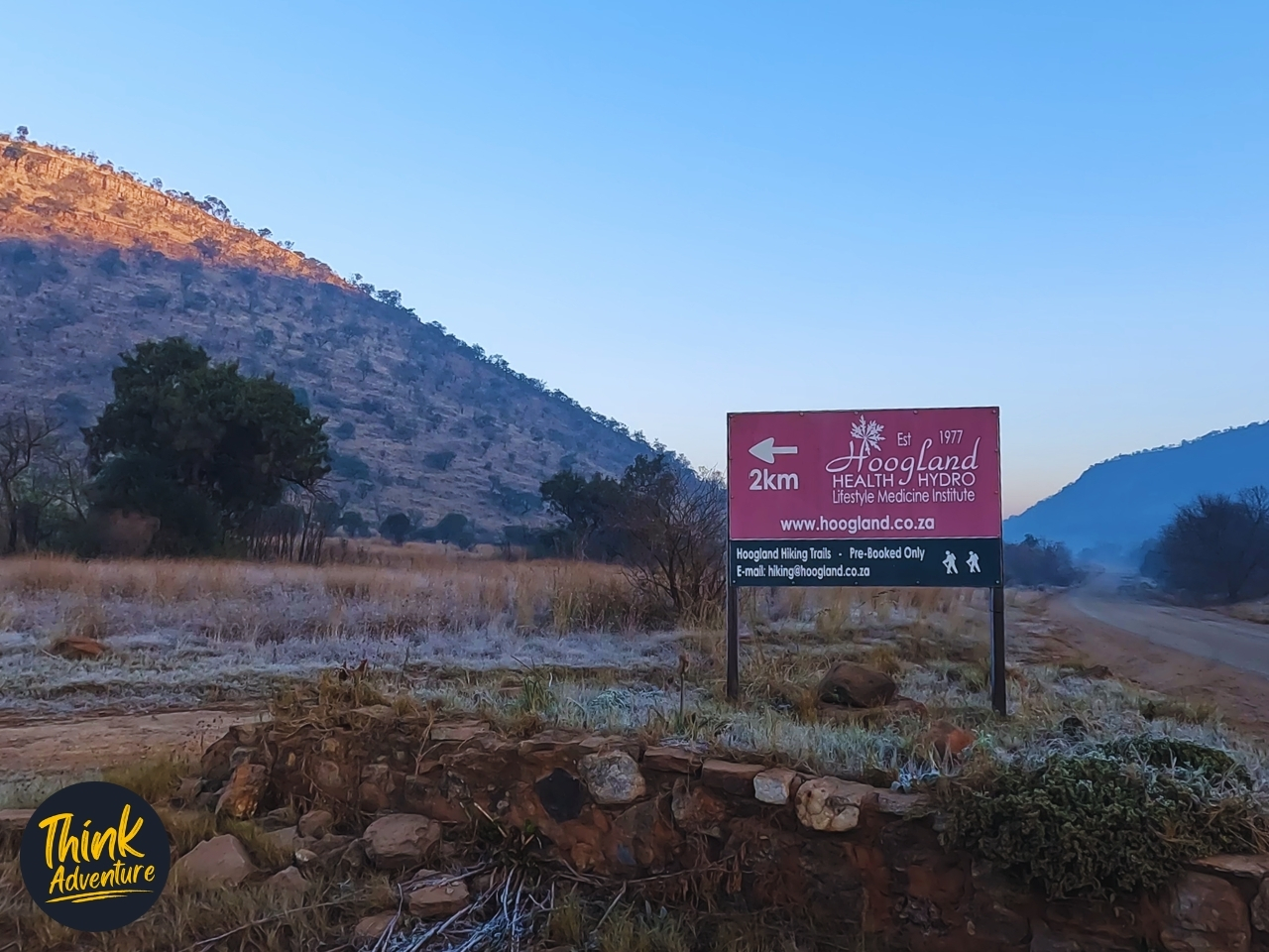
- The turnoff: Watch for the maroon Hoogland Health Hydro sign (Est. 1977) on the dirt road — it marks the left turn toward the property. The board also reads “Hoogland Hiking Trails — Pre-Booked Only.”
- The final stretch: The last 6.4km is dirt road. Fine in a normal car; just take it slow.
- At the gate: A gatekeeper checks your pre-booked permit, photographs your number plate, and directs you to the parking area, which doubles as the start point.
- Map pin: Hoogland Hiking Trails on Google Maps
- Address: Schurveberg Road, Centurion
What to Expect on the Trail
- Surface: A mix of grassland path and rock. In places the rock forms natural step-like sections on the climb. Assessed in dry winter conditions — it would likely be a different, more slippery proposition after rain.
- Navigation: Not a concern. The cave hike is guided from start to finish, and Hoogland is otherwise a network of trails.
- The Payoff: The Dolomite Beacon, one of two high points on the property, with views as far as Pelindaba toward Hartbeespoort on a clear day. Then a short descent to the Main Cave.
- The Cave: A guided look only. You go in about 20m to the edge of a 6m drop — roped, and off-limits to descend. It’s a quick in-and-out, not a show cave. Set your expectations accordingly: think of a wild, still-being-studied hole in a mountain, not Sudwala.
- Technical Sections / Hazards: The cave edge is the main one — a real drop, which is part of why a guide is mandatory.
Why You Need a Guide
Cave visits at Hoogland must be done with a Hoogland guide. The rest of the trail network is self-guided, but the cave is not — partly because it’s dangerous, and partly because the caves are still being researched and the operators are protecting that work.
What to Bring
- Footwear: Trail shoes or boots with proper grip. The rocky sections reward it.
- Torch / Headlamp: Bring your own. You’ll need it in the cave.
- Water: Carry your own — there are no drinkable water sources on the route.
- Snacks: Bring your own.
- Layers: Winter mornings up here start cold and warm up fast once you’re climbing.
Safety & Logistics
- Cell Signal: Likely good throughout — Hoogland sits right on the edge of the city, so coverage in the area is reliable. I didn’t specifically test reception at the beacon, but you shouldn’t be far from the signal at any point.
- Water Sources: None to rely on. Carry what you’ll drink.
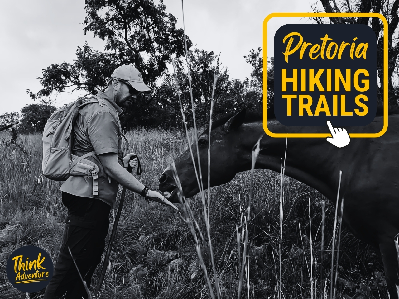
- Snakes & Wildlife: Nothing seen on this winter hike. As Highveld grassland, snakes are a warm-season consideration rather than a winter one — stay alert in summer. Hoogland also keeps horses that roam the property.
- Emergency / Queries: Hoogland on +27 84 830 4000 or hiking@hoogland.co.za.
Cost & Booking
- Cost: R100 per adult (correct at time of writing).
- Pre-booking is required — you cannot just arrive, and a pre-purchased permit is checked at the gate.
- Via a hiking club: This hike ran with the Centurion Hiking Club, who arranged the booking.
- Book direct with Hoogland: via hoogland.co.za or their Facebook page. Email hiking@hoogland.co.za or call +27 84 830 4000.
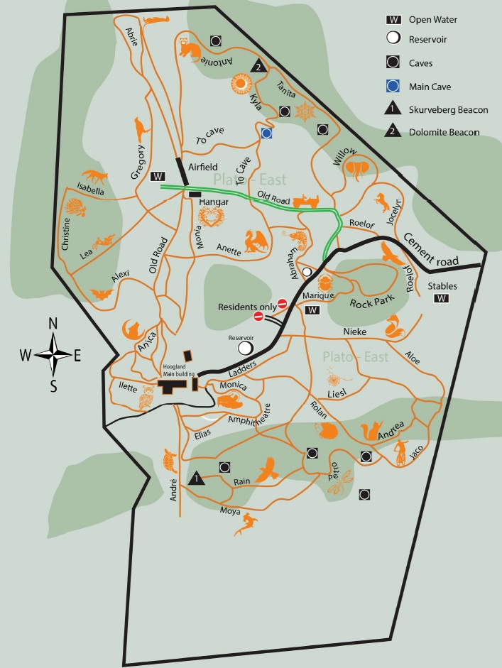
Supporting Media
Hoogland Hiking Trails Map
The Verdict
A short, honest, well-run morning out close to Centurion. Go for the climb, the beacon view, and the novelty of a wild cave that’s still being studied — not for a polished underground tour. Best in winter. Suited to anyone reasonably active; just respect the 283m of climb. Worth it.
Frequently Asked Questions – Hoogland Hiking Trails
Do you need to book in advance for Hoogland Hiking Trails?
Yes, pre-booking is strictly essential before arriving at Hoogland Hiking Trails. Because the paths are located within a private game reserve and health hydro, the venue enforces strict capacity limits to preserve the tranquil environment. You can secure your spot by contacting the administration directly via phone or email.
Are Hoogland Hiking Trails suitable for beginners?
Yes, Hoogland Hiking Trails are suitable for beginners, as the property features over 30 kilometers of paths ranging from short, gentle strolls to strenuous climbs. While the terrain is often rocky, the routes are well-mapped and easy to follow. Beginners should simply choose the shorter, lower-altitude loops to avoid the steep mountain inclines.
Where are the Hoogland Hiking Trails located?
Hoogland Hiking Trails are located inside the Hoogland Hydro Game Reserve along Schurweberg Road in the Hennopsriver Valley, just outside Centurion and Pretoria. The venue sits within a 400-hectare private conservation area in the Schurweberg mountain range. It is easily accessible by standard passenger vehicles, less than an hour’s drive from both Johannesburg and Pretoria.
Can you see wildlife on the Hoogland Hiking Trails?
Yes, you can frequently see wildlife and diverse birdlife while walking on the Hoogland Hiking Trails. The paths wind through a protected conservation area that is home to free-roaming game, indigenous plant life, and unique geological formations. Hikers can also spot historic forests, ancient archaeological features, and even explore hidden caves along the upper ridges.
What should I pack for a day hike at Hoogland?
You must pack all your own basic supplies, including plenty of water, energy snacks, sun protection, and a headlamp if you plan to explore the caves. There are no retail stops on the open trails, with very little shade under the midday sun. Sturdy, worn-in hiking shoes or trail runners are highly recommended for navigating the rugged, rocky terrain.