The sound stopped me. Low, nasal, somewhere between a grunt and a complaint — and close. I stood still on the gravel and turned my head, trying to put a name to it. Nothing came. I’ve walked enough of these trails to know most of what lives out here by ear, and this wasn’t on the list.
Then I looked up at the koppie, and there they were. 2 blue wildebeest, up on the high ground, watching me with the mild contempt only a wild animal can manage. In all my times on this reserve I’d never seen them here. I lifted the camera and that was enough — they turned and moved along, leaving me standing in the grey with the morning I’d very nearly skipped.
Klapperkop is 14km from my driveway — about 20 minutes, door to trailhead. Close enough that I don’t really have an excuse, which doesn’t always help.
That morning I stood at the bedroom window for a while, looking at the sky and trying to decide whether I could be bothered. It was grey, cold, and the wind was up. Winter doing winter things. I checked the forecast, mostly hoping it would make the decision for me — but there was no rain coming, and rain was the one thing I’d actually have stayed in for.
So that was that. I’d walked the Oubaas Trail at Smuts House the day before, the week at work had been rough, and I wanted something that asked a bit more of me. The Red Trail — 9km on the map — would do.
I parked, geared up, and went to find the gatekeeper. Asked her about the trails, got what I needed. No fee to walk here, which is its own small pleasure. Then I made my way to the start of the Red Trail and got going.
The Red Trail starts by going down. A zig-zag descent on gravel that drops you off the high ground almost straight away, which feels backwards when you’ve come to climb. The reserve gains about 302m over the loop, but it gives most of it back to you early — you spend the first stretch quietly aware that everything you’re losing now is a debt the trail will call in later.
The sky still hadn’t done anything. Grey, low, the blue nowhere in sight. I’d stopped at a low point on the trail to try a few photos, not expecting much in the grey light, when the wildebeest found me — or I found them. After they’d moved off I stood a moment in the space where they’d been, then carried on.
From there the trail just keeps being honest about its shape. Down, up, down again, gravel underfoot the whole way, long stretches of it shaded under trees. It’s shared ground — mountain bikers and trail runners use the same paths — so part of the job is listening. You learn to keep half an ear behind you for the hum of a freewheel or footsteps closing in. That early on a Sunday it didn’t matter much. I passed 2 trail runners and had 1 mountain biker come by, and that was it. Early start, grey weather, a Sunday — I assume most people took one look outside and decided bed was the better option.
My legs felt good through the first half — that easy, willing feeling you get on a downhill that hasn’t asked for anything yet. The second half is where the trail collects. The climb back up is honest work, and somewhere on it I started to feel the legs working hard for the first time, which after the day before was about what I’d expected.
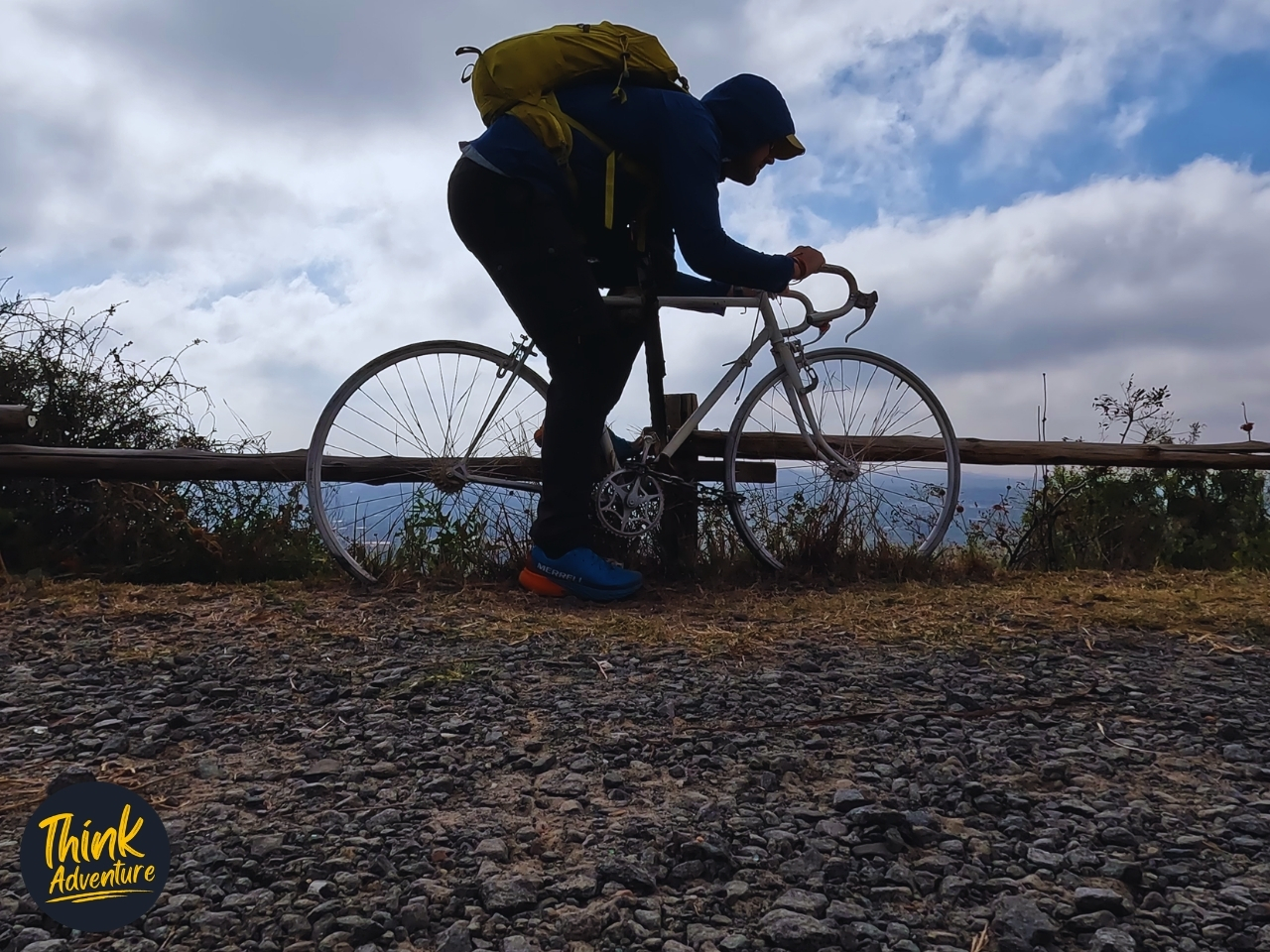
The reserve has viewpoints set along the loop, and near the top of the second half I reached one I know. The view was the same as always — but this time a big yellow frame had been added, the kind you stand inside so the camera catches you against the drop. The old white road bike was still parked next to it, same as I’ve seen it before. New frame, familiar bike. I stopped and spent a few minutes working the shot from a few angles. By now the grey was breaking up. You could feel the day deciding to turn.
Somewhere along here I caught it too — the smell of the highveld in winter. Dry grass, dirt and cold air. Hard to describe to anyone who hasn’t smelled it, easy to recognise if you have.
The last climb puts you on the highest ground of the whole loop, and there’s a radio tower up there — a tall lattice mast, red and white, antennas and dishes bolted up its length, the kind of structure you usually drive past without a second look. Up close, craning your neck at the base of it, it’s a different thing. It just goes up, narrowing into the blue until the top feels a long way off.
And the blue was the thing. The grey I’d started in was gone — properly gone, not thinning, just gone. Somewhere over the last hour the sky had pulled itself apart into deep blue and big slow clouds, and from up there you could see the whole of it at once. Pretoria spread out below, hazy and flat and going on for miles. Left to right you can pick out the University of Pretoria’s Groenkloof campus, the Telkom Tower breaking the horizon, and the South African Bureau of Standards offices. The koppies ran off into the distance on either side.
I’d come up expecting nothing. I’d stood at the bedroom window that morning half-looking for an excuse to stay home, and here I was at the top of it under a sky that had decided, somewhere along the way, to turn into a good day. I took my time. Finished off my travel snacks, had a drink, took in the view. Then I got back on the trail.
The walk back down let my legs know they’d done the work. By the time I reached the car I could feel the whole loop in them — not sore, just a good workout, the honest kind of tired. Still morning, too. Not even midday yet.
I sat for a minute before starting the engine. Same grey start I’d nearly talked myself out of, now a bright late morning. Quietly satisfied, glad I came. The window had said stay home. The window doesn’t get a vote.
The Practical Guide – Klapperkop Red Trail
Everything you need to walk the Red Trail at Fort Klapperkop Nature Reserve, Pretoria. No storytelling here — just the facts. Prices and details correct at time of writing.
The Basics
- Activity: Self-guided hiking (trail also shared with trail runners and mountain bikers)
- Location: Fort Klapperkop Nature Reserve, Groenkloof, Pretoria, Gauteng
- Trail: Red Trail
- Difficulty: Easy to Moderate, depending on your fitness level
- Distance: 9km on the official reserve map (9.32km on my GPS)
- Elevation gain: 302m
- Moving time: 2:12:54 (just over 2 hours at a relaxed pace, with photo stops)
- Best time of year: All year. Just be comfortable hiking in the season you pick — highveld winters are cold and dry, summers are hot with afternoon thunderstorms.
- Klapperkop Nature Reserve on Strava
Difficulty Rating
I rate trails on a simple 3-tier scale, used consistently across all articles on the site:
Easy — gentle, suitable for most people and a casual outing
Moderate — some real climbing or distance; a decent level of fitness helps
Hard — long, steep, technical, or exposed; for fit and experienced hikers
The Red Trail sits at Easy to Moderate. There’s nothing technical about it — it’s an honest gradient on gravel. What pushes it towards Moderate is the 302m of climbing packed into 9km, most of which you earn on the second half of the loop. Fit walkers will find it comfortable. If you’re newer to hiking, it’s very doable — just expect the legs to know about it on the climb back up.
Getting There
- Address: Johann Rissik Dr, Groenkloof 358-Jr, Pretoria, 0027
- Klapperkop Nature Reserve on Google Maps
- Parking: Available at the reserve. It’s limited, so an earlier start on weekends is wise.
Hours & Cost
- Gate times: 06:00–18:00, daily
- Cost to hike: Free. There is no fee to enter the nature reserve or walk the trails.
- Reserve contact: City of Tshwane, 012 358 1757
- Website: www.tshwane.gov.za/groenkloofnaturereserve
What to Expect
- A loop that descends first in a zig-zag off the high ground, works its way around the reserve, then climbs back up — so the bulk of the effort is in the second half.
- Surface: gravel throughout, with long stretches shaded under trees.
- Shared trails: mountain bikers and trail runners use the same paths. Keep half an ear open behind you, especially on the narrower, tree-covered sections.
- Navigation: well marked. The Red Trail follows red markers, and the reserve uses colour-coded posts at junctions (yellow, green, red, blue). No wrong turns needed if you watch the markers.
- Hazards: none technical — just the gradient. Good footwear handles it comfortably.
What to Bring
- Water: Bring your own. There are no drinkable water sources on the trail.
- Footwear: Trail shoes or hiking shoes. The gravel is easy underfoot but a proper sole makes the descents and climbs more comfortable.
- Sun protection: Cap, sunscreen, sunglasses — sections are exposed, and the highveld sun is strong even in winter.
- Layers: In winter, start warm; it’s cold early and the wind bites on the tops. You’ll shed layers on the climb.
- Snacks: Worth packing something for a break at one of the viewpoints.
Good to Know
- Wildlife: Plains game only — zebra are common, and you may spot blue wildebeest or red hartebeest. Nothing dangerous. Small mammals (mongoose, hares, porcupine) are present but rarely seen.
- Snakes: No more than standard highveld bushveld caution. Watch where you step in the warmer months; nothing trail-specific to flag.
- Cell signal: Good across the whole trail.
- Reserve size: c. 460 ha
- Other trails in the reserve (official reserve map distances):
- Blue — 4.2km
- Red — 9km (this route)
- Green — 9km
- Yellow — 10km
- Fort Klapperkop museum: The restored 1898 fort at the top of the hill is a separate attraction with its own entrance fee (around R22–R30 at time of writing) and its own opening hours (generally Tuesday–Sunday, closed Mondays). Worth combining with the hike if military history interests you — confirm hours and fee on the day, and bring cash.
- Nearby: The Groenkloof Spar is an easy stop on the way home and is well known for its croissants.
Safety & Logistics
- Hike in daylight and stick to the gate hours. The reserve gate is manned by officials.
- As with several Pretoria reserves, it’s sensible to hike with awareness and keep valuables out of sight.
- Emergency: note the reserve contact number above before you set off, and carry a charged phone — signal is reliable throughout.
- See PRETORIA: Emergency Contact Numbers
Klapperkop Nature Reserve Trails Map

The Verdict
Who should do this: Anyone reasonably mobile who wants a proper Pretoria view without a serious mission. It’s close to the city, free, well-marked, and forgiving — a good introduction to longer trail walking, and an easy regular loop if you live nearby.
Who might skip it: If you want technical terrain, scrambling, or wilderness solitude, this isn’t that — it’s a shared, well-trodden reserve loop close to the suburbs.
Worth it? Yes. For a free, 9km loop 20 minutes from the city centre, the views over Pretoria from the top of the climb — the University of Pretoria’s Groenkloof campus, the Telkom Tower, the SABS offices laid out below — are hard to beat. Pick a clear day and it delivers well above what it costs you.
Difficulty: Easy to Moderate · Distance: 9km · Time: ~2 hours · Cost: Free
Frequently Asked Questions – Klapperkop Nature Reserve Trails
How much does it cost to hike at Klapperkop Nature Reserve?
Entrance to the Klapperkop Nature Reserve hiking trails is completely free. There are no conservation fees or vehicle permits required to access the self-guided trails, picnic spots, or viewpoints. Visitors simply need to sign in and out at the manned main gate upon arrival.
Is hiking at Klapperkop Nature Reserve safe?
Hiking at Klapperkop is generally safe during peak weekend hours, but caution is highly advised due to a history of muggings. Security has improved with access controls, manned gates, and local community patrols. It is strongly recommended to hike in groups rather than alone and to remain vigilant.
What are the opening hours for the Klapperkop hiking trails?
The reserve gates are officially open daily from 06:00 to 18:00, with the last entry permitted at 17:00. These strict daylight hours were implemented by the City of Tshwane to improve visitor safety. Guard reliability can occasionally vary early in the morning, so a backup plan is wise.
How long is the green hiking trail at Klapperkop?
The green route at Klapperkop Nature Reserve is a moderate 9-kilometer circular trail. The first 2 kilometers are relatively flat along the reserve boundary, followed by a rugged, rocky ascent up the ridge. It offers panoramic views of Pretoria and takes roughly two to three hours to complete.
Can you see wildlife while hiking at Klapperkop?
Yes, you are highly likely to encounter large game species like zebras, blue wildebeest, and red hartebeest while out on the trails. The 460-hectare reserve is also home to smaller, nocturnal mammals like mongooses, porcupines, and hares, alongside a rich variety of indigenous birdlife.
